Wind Chill Advisory overnight tonight into Monday
January 19, 2020 8:35PM CST
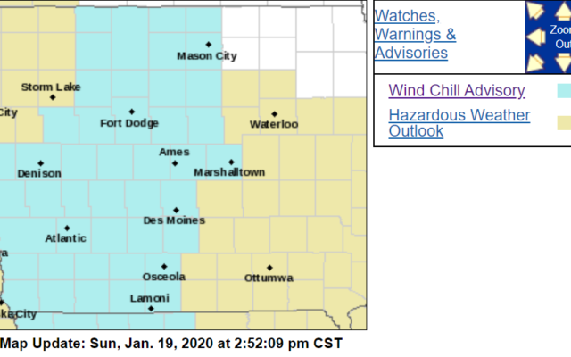
...Bitter Cold Wind Chills Again Tonight Into Monday...

.Temperatures will fall well below zero tonight, with wind chill
values falling to 20 below or lower once again.

IAZ004>007-015>017-023>026-033>037-044>049-057>060-200500-
/O.NEW.KDMX.WC.Y.0003.200120T0000Z-200120T1500Z/
Emmet-Kossuth-Winnebago-Worth-Palo Alto-Hancock-Cerro Gordo-
Pocahontas-Humboldt-Wright-Franklin-Sac-Calhoun-Webster-Hamilton-
Hardin-Crawford-Carroll-Greene-Boone-Story-Marshall-Audubon-
Guthrie-Dallas-Polk-
Including the cities of Estherville, Algona, Forest City,
Lake Mills, Northwood, Manly, Emmetsburg, Garner, Britt, Kanawha,
Mason City, Clear Lake, Pocahontas, Laurens, Rolfe, Fonda,
Gilmore City, Humboldt, Eagle Grove, Clarion, Belmond, Hampton,
Sac City, Lake View, Odebolt, Wall Lake, Schaller, Early,
Rockwell City, Manson, Lake City, Pomeroy, Fort Dodge,
Webster City, Iowa Falls, Eldora, Ackley, Denison, Carroll,
Jefferson, Boone, Ames, Marshalltown, Audubon, Exira,
Guthrie Center, Panora, Bayard, Casey, Perry, Waukee, Adel,
and Des Moines
252 PM CST Sun Jan 19 2020

...WIND CHILL ADVISORY IN EFFECT FROM 6 PM THIS EVENING TO 9 AM
CST MONDAY...

* WHAT...Very cold wind chills of 20 to 25 below zero.

* WHERE...Most of northern, central, and western Iowa.

* WHEN...From 6 PM this evening to 9 AM CST Monday, with the
  coldest wind chills during the overnight and early morning
  hours.

* IMPACTS...Frostbite could occur on exposed skin in as little as
  30 minutes.

PRECAUTIONARY/PREPAREDNESS ACTIONS...

Use caution while traveling outside. Wear appropriate clothing, a
hat, and gloves.