❄ Moderate to at Times Heavy Snowfall over Northern Iowa into this evening ❄
…Hazardous Travel Today with Moderate to at Times Heavy Snowfall over Northern into Central Iowa…
Snow has moved into western Iowa and is beginning to push toward the Highway 169 corridor as the clock ticks near 3am. Snowfall will continue to advance eastward over northern and central Iowa early this morning and persist much of the day over the northern half of the state.
The highest snowfall rates will be this morning and lead to visibility as low as around a half a mile over northern into at times central Iowa. Sustained winds of 10 to 20 mph with gusts up to around 25 mph will also cause some blowing snow, which of course will be the worst when there is falling snow. With rates lessening into this afternoon and evening, the visibility reduction will not be as low.
Amounts will be the highest north of Highway 20 up to around Highway 18 with a quick drop off in amounts to the south toward Interstate 80 and to the north toward the Iowa Minnesota border. As the precipitation diminishes later in the afternoon into early this evening, there may also be freezing drizzle mixed in at times generally along and south of Highway 30.
…WINTER STORM WARNING UNTIL 9 PM THIS EVENING FOR CERRO GORDO, HANCOCK, KOSSUTH, WRIGHT, FRANKLIN AND BUTLER COUNTIES…
Heavy snow is expected. Total snow accumulations of 5 to 7 inches, with locally higher amounts possible.
…WINTER WEATHER ADVISORY UNTIL 9 PM THIS EVENING FOR WORTH AND WINNEBAGO COUNTIES…
Snow expected possibly with freezing drizzle. Total snow accumulations of 2 to 4 inches.
…WINTER WEATHER ADVISORY UNTIL 10 PM THIS EVENING FOR FLOYD, MITCHELL AND MOWER MN…
Snow is expected. Total snow accumulations of 3 to 6 inches.
…WINTER WEATHER ADVISORY UNTIL 10 PM THIS EVENING FOR FREEBORN AND FARIBAULT COUNTIES IN SOUTHERN MINNESOTA…
Snow. Additional snow accumulations of 1 to 3 inches.
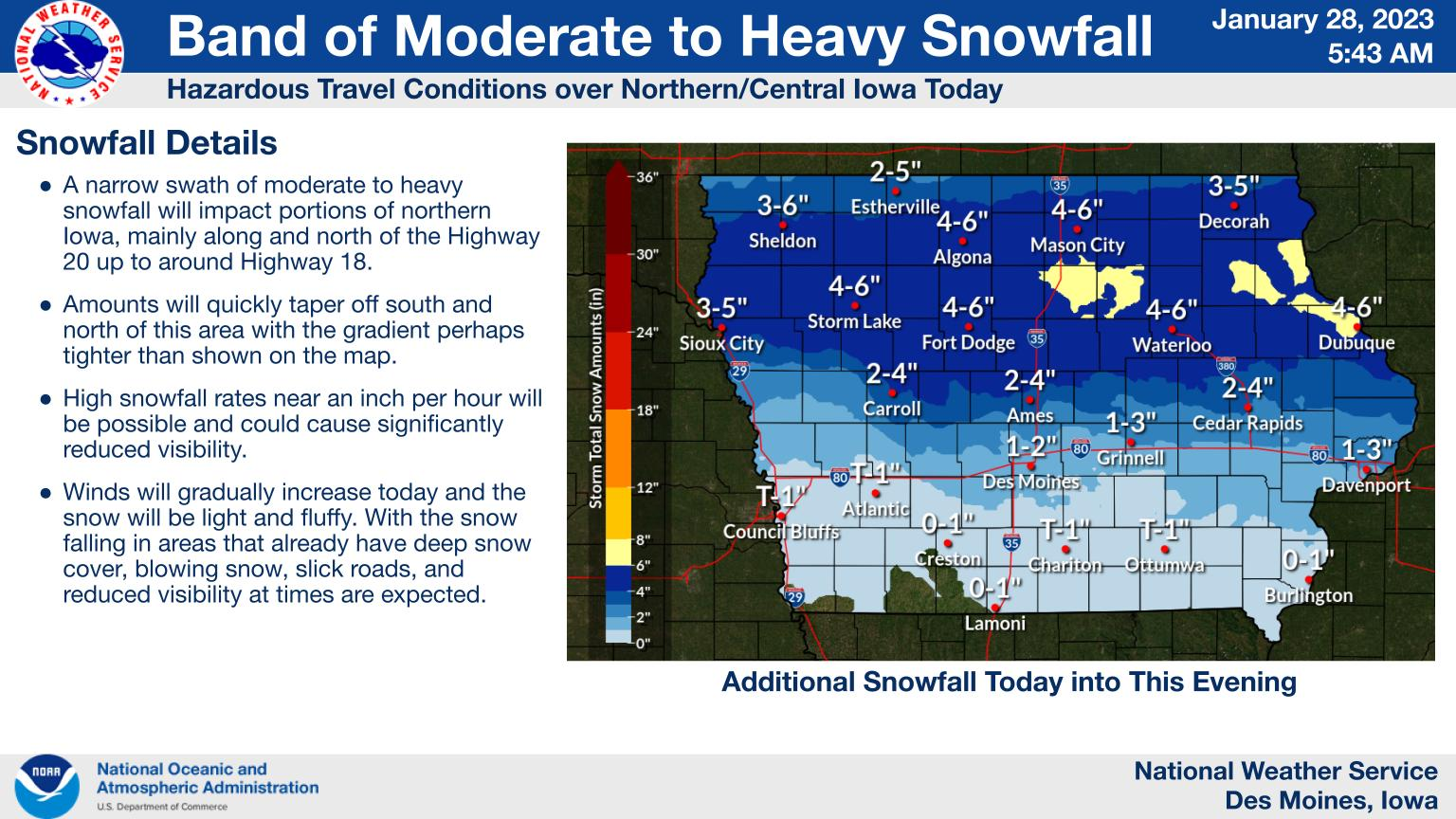
Snowfall will continue to advance eastward over northern and central Iowa early this morning and persist much of the day over the northern half of the state. The worst conditions will be this morning over northern Iowa with the highest snowfall rates and visibility as low as a half a mile due to a combination of falling and blowing snow. Over southern Iowa, snow may mix with freezing drizzle this afternoon and evening. All of the wintry precipitation will come to an end tonight from west to east. Snowfall totals will be the highest north of Highway 20 up to around Highway 18 of 5 to 7 inches with locally higher amounts possible. Totals will drop off quickly to the north and south of this band.
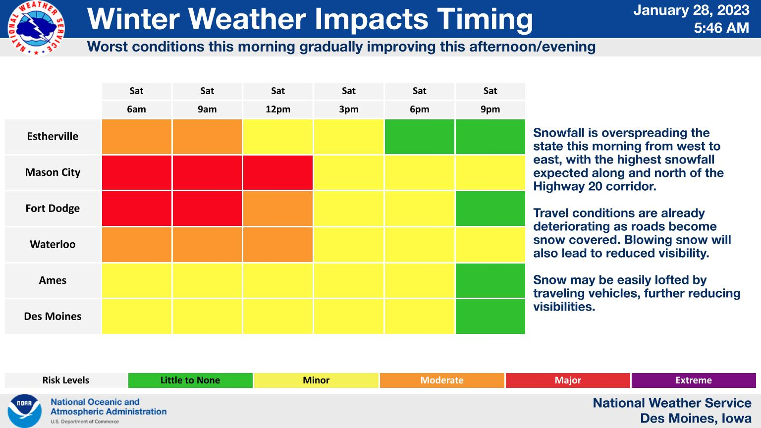
The worst conditions will be this morning over northern Iowa with the highest snowfall rates and visibility as low as a half a mile due to a combination of falling and blowing snow. With rates lessening into this afternoon and evening, the visibility reduction will not be as low. All of the wintry precipitation will come to an end tonight from west to east.
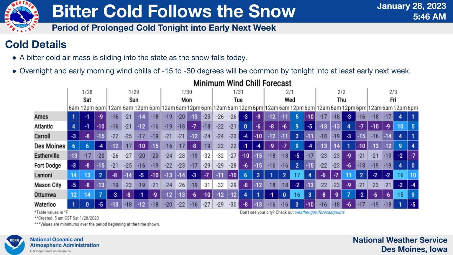
As colder air filters in and with breezy winds tonight, wind chills of 20 degrees below zero or lower will be common over roughly the northwestern half of the state by Sunday morning. Cold conditions will persist into the first half of the week with similar bitter cold wind chills each overnight and morning through Tuesday morning with the worst conditions over northern Iowa.