Dangerous travel today with snow and blizzard conditions expected
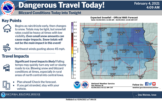
Please reconsider travel this morning and afternoon; especially over Northern and portions of Central to eastern Iowa where blizzard conditions are expected.
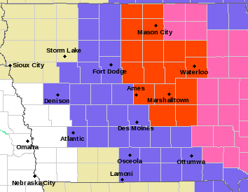
…BLIZZARD WARNING IN EFFECT UNTIL 6 AM CST FRIDAY FOR CERRO GORDO, WORTH, WINNEBAGO, HANCOCK, KOSSUTH, FRANKLIN, BUTLER AND WRIGHT COUNTIES….
Blizzard conditions expected. Total snow accumulations of 2 to 5 inches. Winds gusting as high as 45 mph. Visibilities one-quarter mile or less especially in rural areas. Expect refreezing on wet pavement areas near sunset. Travel should be restricted to emergencies only. If you must travel, have a winter survival kit with you. If you get stranded, stay with your vehicle.
…WINTER STORM WARNING UNTIL MIDNIGHT TONIGHT FOR FLOYD AND MITCHELL COUNTIES…
Blowing snow. Winds gusting as high as 40 mph.
…WINTER WEATHER ADVISORY UNTIL MIDNIGHT TONIGHT FOR KOSSUTH COUNTY…BLIZZARD WARNING CANCELLED…
Blowing snow. Winds gusting as high as 40 mph.
…WINTER WEATHER ADVISORY UNTIL MIDNIGHT TONIGHT FOR MOWER MN…
Snow ending. Winds gusting as high as 35 mph. These winds will result in some blowing and drifting snow.
…WINTER WEATHER ADVISORY UNTIL 9 PM THIS EVENING FOR FREEBORN AND FARIBAULT COUNTIES IN SOUTHERN MINNESOTA…
Snow. Additional snow accumulations of up to one inch. Winds gusting as high as 35 mph.
For more and the complete county by county breakdown from the National Weather Service click below!