BLIZZARD WARNING through early Saturday morning.


….WINTER STORM WARNING IN EFFECT UNTIL NOON TODAY….BLIZZARD WARNING IN EFFECT FROM NOON THURSDAY UNTIL 6 AM SATURDAY FOR CERRO GORDO, WORTH, WINNEBAGO, HANCOCK, WRIGHT, KOSSUTH, FRANKLIN AND BUTLER COUNTIES…
For the Winter Storm Warning, heavy snow. Additional snow accumulations of 1 to 3 inches. Winds gusting as high as 40 mph this morning. For the Blizzard Warning, blizzard conditions are expected. Winds gusting as high as 50 mph or more. Extreme cold and wind chills of 20 to 40 below zero will be common and dropping to near 45 below tonight and Friday morning.
…WINTER STORM WARNING IN EFFECT UNTIL 6 PM THIS EVENING…BLIZZARD WARNING FROM 6 PM THIS EVENING UNTIL 6 AM SATURDAY FOR FLOYD MITCHELL AND MOWER MN…
For the Winter Storm Warning, snow. Additional snow accumulations of up to one inch. Winds gusting as high as 40 mph. For the Blizzard Warning, blizzard conditions are expected. Winds gusting as high as 50 mph.
…WINTER STORM WARNING IN EFFECT UNTIL TODAY THURSDAY… BLIZZARD WARNING IN EFFECT FROM NOON TODAY UNTIL 6 AM CST SATURDAY….WIND CHILL WARNING FROM FROM 6 PM THURSDAY UNTIL NOON ON SATURDAY FOR FREEBORN AND FARIBAULT COUNTIES IN SOUTHERN MINNESOTA…
For the Winter Storm Warning, blowing snow is expected. For the Blizzard Warning, whiteout conditions are expected. Winds gusting as high as 45 mph. For the Wind Chill Warning, dangerously cold wind chills are expected. Wind chills as low as 40 below zero.
The combination of blowing snow, blizzard conditions, and extreme cold will be extremely hazardous and life threatening if stranded outside.
Those with holiday travel planned through Friday night are strongly encouraged to pay close attention to forecast updates and road conditions, and prepare accordingly if travel is a must. Altering travel plans, if possible, is strongly encouraged.
Snow will be ending from west to east but the wind will increase leading to significant blowing and drifting of snow. Blizzard conditions are likely for much of central and northern Iowa late this afternoon and into Friday.
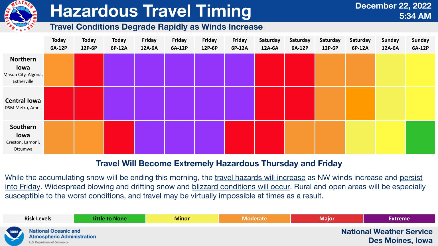
Arctic cold air combined with strong northwest wind will create wind chill values of 30 to 40 below today and near 45 below at times tonight into Friday morning. These temperatures could be life threatening should you become stranded and this makes travel very hazardous through Friday due to significant blowing and drifting of snow and blizzard conditions at times.