A WINTER STORM WARNING remains in effect until 4 PM this afternoon
…Quick Hitting Spring Storm to Bring Moderate to Heavy Snow to Northern Iowa Today…
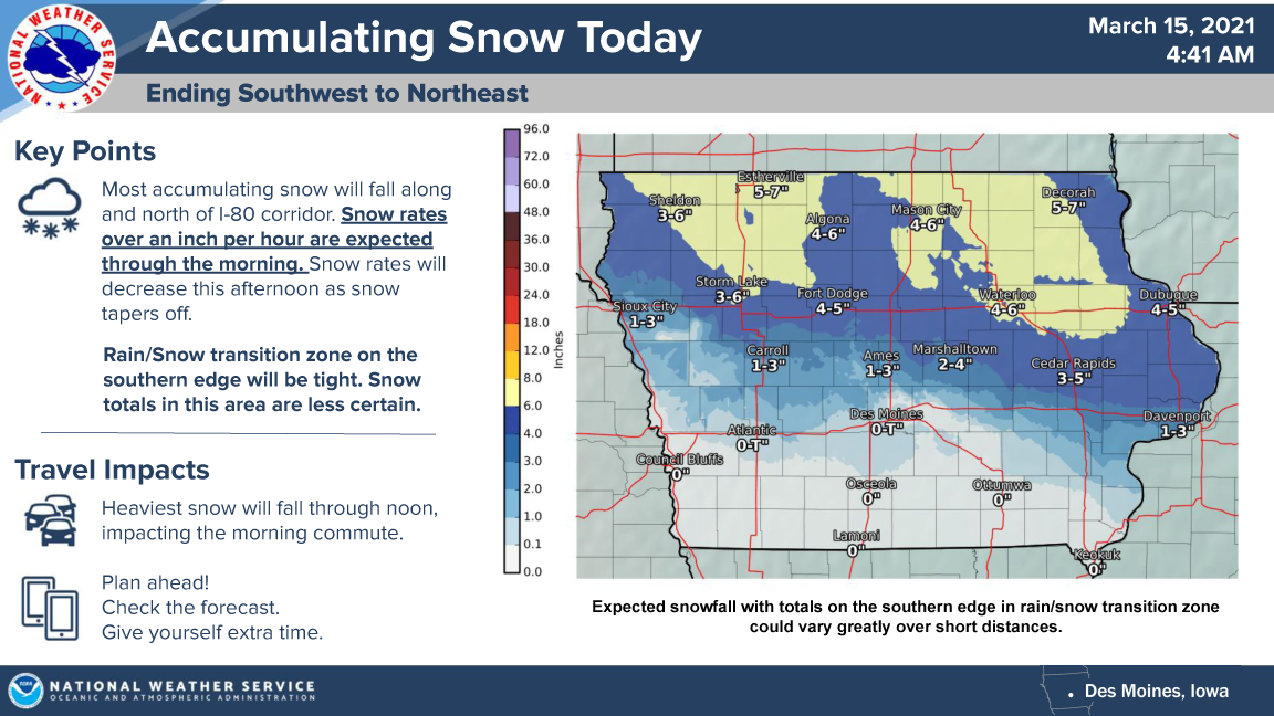
A strong early spring storm system continues to move across Iowa this morning. A majority of the snow accumulation will be north of Interstate 80, but some minor accumulation has occurred towards the highway 94 corridor already this morning. Northern Iowa will see snow accumulations exceed 6 inches with areas. The heaviest snow will fall before noon today, impacting the morning commute with snow rates over an inch per hour over much of the warned area.

…WINTER STORM WARNING IN EFFECT UNTIL 4 PM THIS AFTERNOON FOR CERRO GORDO, WORTH, WINNEBAGO, HANCOCK, WRIGHT, KOSSUTH, FRANKLIN AND BUTLER COUNTIES…
Heavy wet snow expected. Total snow accumulations of 5 to 8 inches. Winds gusting as high as 35 mph.
…WINTER STORM WARNING IN EFFECT UNTIL 4 PM THIS AFTERNOON FOR FLOYD AND MITCHELL COUNTIES…
Heavy, wet snow expected, with light freezing drizzle possible. Total snow accumulations of 5 to 7 inches and ice accumulations of a light glaze. Winds gusting as high as 30 mph.
…WINTER STORM WARNING UNTIL 4 PM THIS AFTERNOON FOR MOWER COUNTY IN SOUTHERN MINNESOTA…
Heavy, wet snow expected, with light freezing drizzle possible. Total snow accumulations of 5 to 7 inches and ice accumulations of a light glaze. Winds gusting as high as 30 mph.
…WINTER STORM WARNING UNTIL 4 PM THIS AFTERNOON FOR FREEBORN AND FARIBAULT COUNTIES…
Heavy mixed precipitation. Total snow accumulations of 5 to 8 inches and ice accumulations of a light glaze. Winds gusting as high as 35 mph.
For the latest information from the National Weather Service click on the link below!