❄Winter Storm Watch for Franklin and Butler counties❄
…Winter Storm to Impact the Area Late Tonight into Thursday Morning…
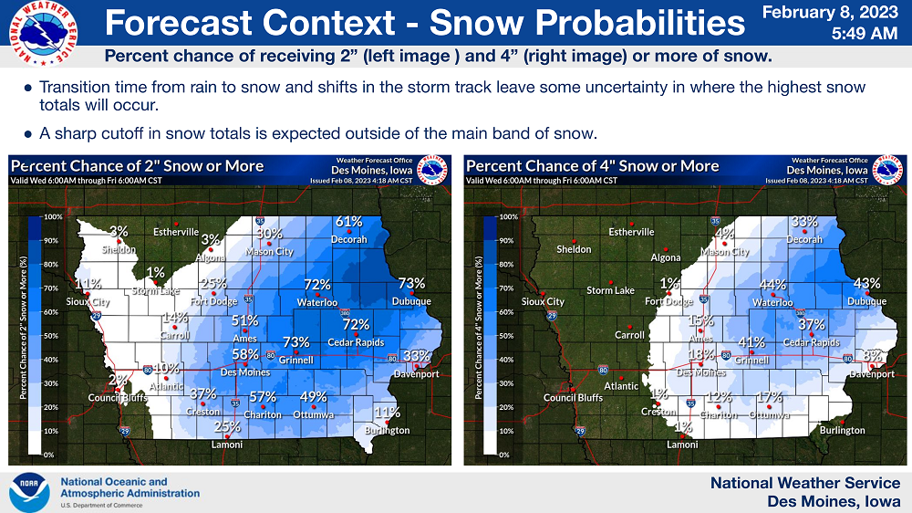
A winter storm will impact portions of the area with rain transitioning to heavy, wet accumulating snow overnight into Thursday morning. Moderate, to at times heavy, snow is expected with the highest accumulations within a band of heavy snow in portions of east central into northeast Iowa.
Areas outside of the main band will likely see a sharp cutoff in snow totals. A brief period of 1-2 inch per hour snowfall rates will be possible on Thursday morning with impacts to the morning commute expected.
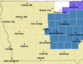
…WINTER STORM WATCH FROM LATE TONIGHT THROUGH THURSDAY MORNING FOR BUTLER AND FRANKLIN COUNTIES…
* WHAT…A band of heavy snow is possible in the watch area. Total snow accumulations of 4 to 7 inches may occur within the band of heavy snow, with lesser amounts in areas that fall outside of the main band. Winds could gust as high as 35 mph.
* WHERE…Portions of East Central Iowa including Franklin and Butler counties of our listening area.
* WHEN…From late tonight through Thursday morning.
* IMPACTS…Plan on snow covered and slick road conditions. The hazardous conditions will impact the Thursday morning commute. Some tree damage and power outages may also occur.
PRECAUTIONARY/PREPAREDNESS ACTIONS…
Monitor the latest forecasts for updates on this situation.