❄Significant Winter Storm Wednesday Into Thursday❄
…Significant Winter Storm with Two Rounds of Precipitation…
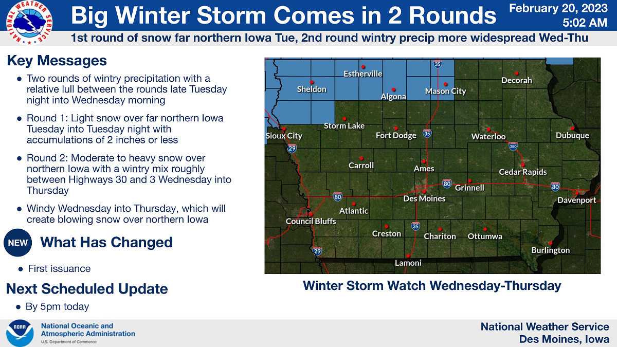
A large winter storm with prolonged wintry precipitation will occur over the region Tuesday through Thursday. The first round will be mainly snow over far northern Iowa with light accumulations possible. Otherwise with this first round, much of Iowa will not see any wintry precipitation.
The second round of wintry precipitation Wednesday into Thursday will be more widespread and be the more impactful portion of this winter storm for the state of Iowa. That is what this Winter Storm Watch covers and additional headlines and areas covered are certainly possible in the coming days. While snow will remain the main precipitation type over northern Iowa, a wintry mix with icing potential is possible mainly between Highway 30 and 3, but may extend as far south as I-80. Farther south for areas south of I-80, mainly rain is expected that may end as a bit of light snow with little if any accumulation. Wednesday into Thursday will also feature strong and gusty winds, which will cause areas of blowing snow over northern Iowa. Needless to say, travel impacts are increasingly likely Wednesday into Thursday over northern into parts of central Iowa and certainly for areas of South Dakota, Minnesota, and Wisconsin as well.
….WINTER STORM WATCH REMAINS IN EFFECT FROM WEDNESDAY MORNING THROUGH THURSDAY MORNING FOR CERRO GORDO, WORTH, WINNEBAGO, HANCOCK AND KOSSUTH COUNTIES…
Heavy mixed precipitation possible. Total snow accumulations of 5 to 11 inches with higher amounts possible towards the Iowa/Minnesota border. Ice accumulations of a light glaze to up to around one tenth of an inch possible. Winds could gust as high as 45 mph.
…WINTER STORM WATCH REMAINS IN EFFECT FROM TUESDAY EVENING THROUGH THURSDAY AFTERNOON FOR MOWER COUNTY IN SOUTHERN MINNESOTA…
Heavy snow is possible. Total snow accumulations of 6 to 12 inches over the course of two days with some locations seeing amounts in excess of a foot. Winds could gust as high as 40 mph.
….WINTER STORM WATCH REMAINS IN EFFECT FROM TUESDAY AFTERNOON THROUGH THURSDAY AFTERNOON FOR FREEBORN AND FARIBAULT COUNTIES IN SOUTHERN MINNESOTA…
Heavy snow with total snow accumulations of 12 to 18 inches possible. Winds could gust as high as 35 to 45 mph late Wednesday into Thursday.

Accumulating light snow will develop over northern Iowa through the day Tuesday and continue into Tuesday night. Snowfall will range up to near 2 inches along the Minnesota border by sunrise Wednesday, with much of Iowa south of Highway 3 not seeing any precipitation during this time. A few minor travel impacts are possible in the far north. 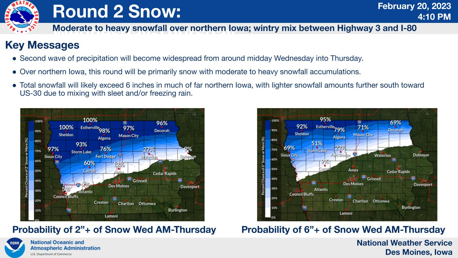
After the far northern Iowa light snow on Tuesday and Tuesday night, winter precipitation will become more widespread from Wednesday into Thursday. While snow will remain the main precipitation type over northern Iowa, a wintry mix with icing potential is possible from around Highway 3 down toward Interstate 80. For areas south of I-80 mainly rain is expected but may end as a bit of light snow with little to no accumulation. Wednesday into Thursday will also feature strong and gusty winds, which will cause areas of blowing snow over northern Iowa. Travel impacts are increasingly likely Wednesday into Thursday over northern into parts of central Iowa as well as much of the neighboring states. 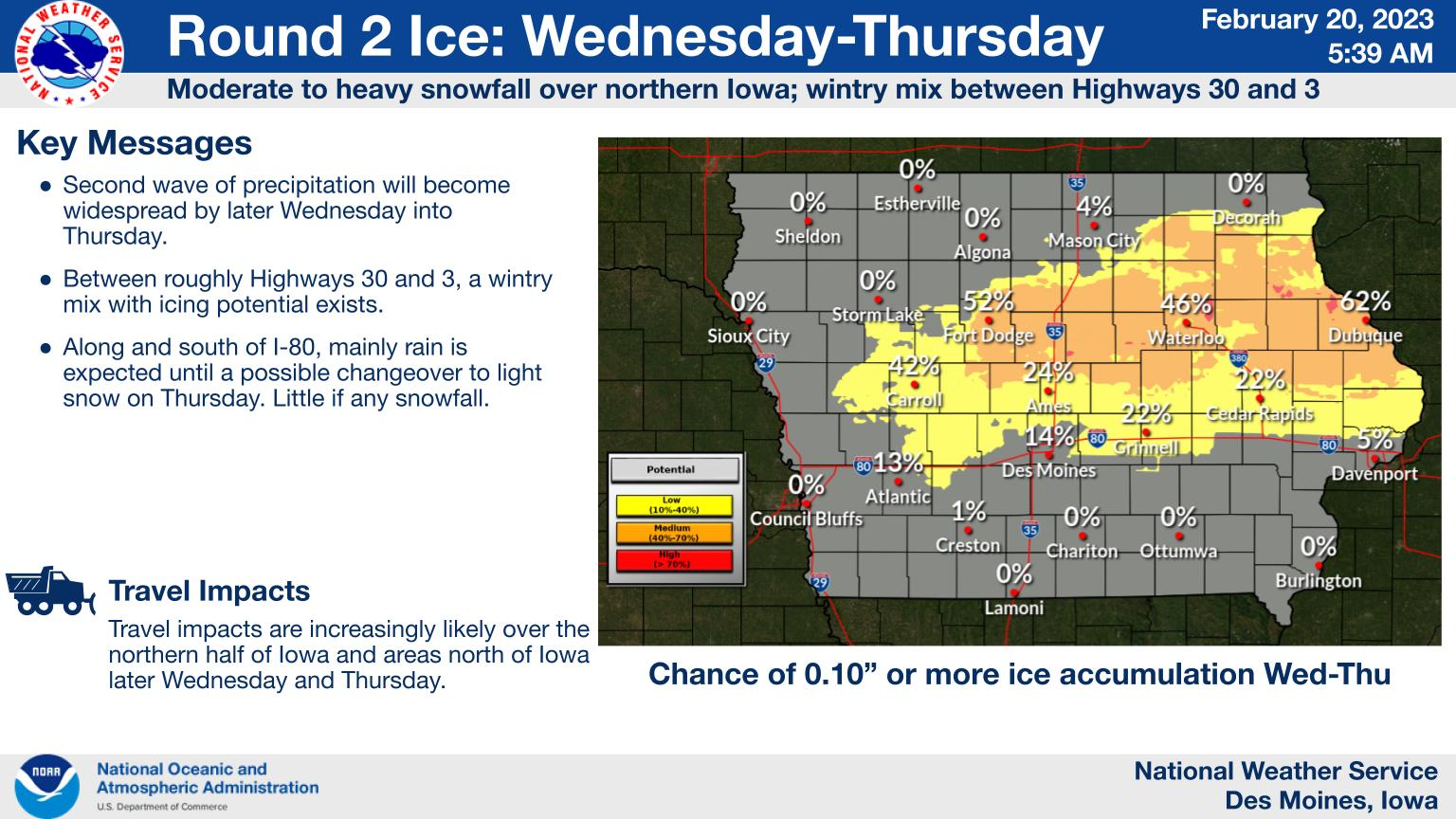
After the far northern Iowa light snow on Tuesday and Tuesday night, winter precipitation will become more widespread from Wednesday into Thursday. While snow will remain the main precipitation type over northern Iowa, a wintry mix with icing potential is possible from around Highway 3 down toward Interstate 80. For areas south of I-80 mainly rain is expected but may end as a bit of light snow with little to no accumulation. Wednesday into Thursday will also feature strong and gusty winds, which will cause areas of blowing snow over northern Iowa. Travel impacts are increasingly likely Wednesday into Thursday over northern into parts of central Iowa as well as much of the neighboring states.
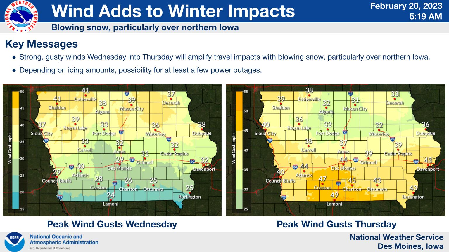 Besides the wintry precipitation, Wednesday into Thursday will also feature strong and gusty winds. This will cause areas of blowing snow over northern Iowa, with travel impacts increasingly likely from the wintry precipitation and blowing snow Wednesday into Thursday over northern into parts of central Iowa as well as much of the neighboring states.