❄🧊A Winter Storm Warning and a Ice Storm Warning are in effect 🧊❄
…Significant Winter Storm Wednesday Into Thursday…
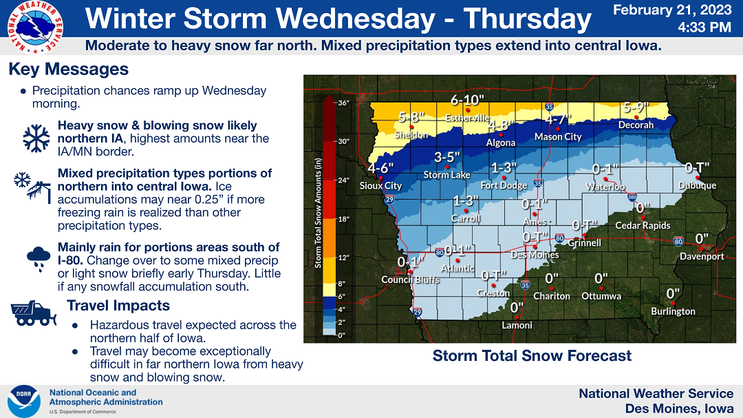
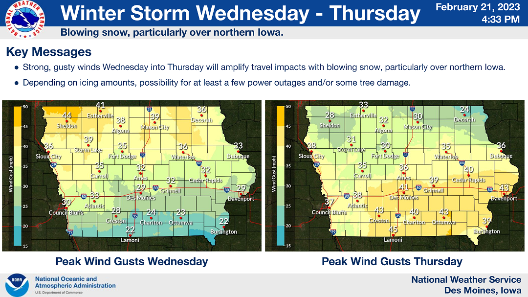
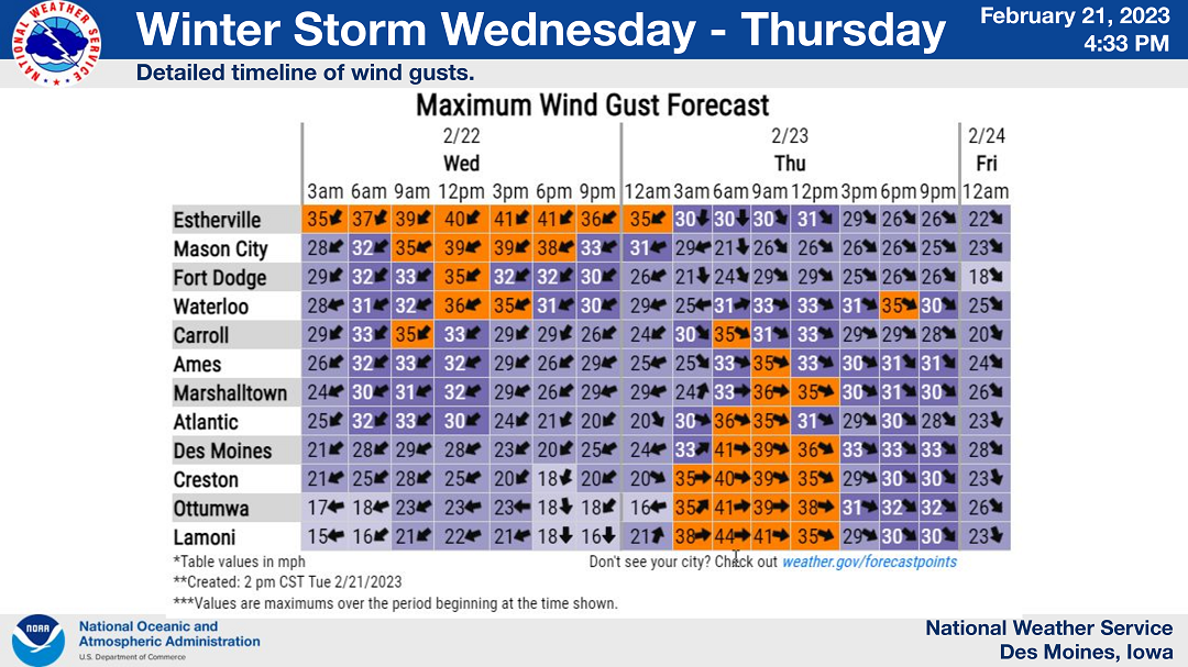
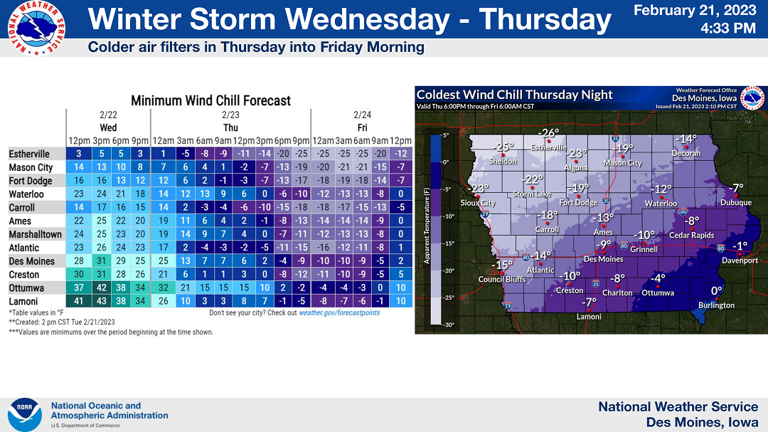
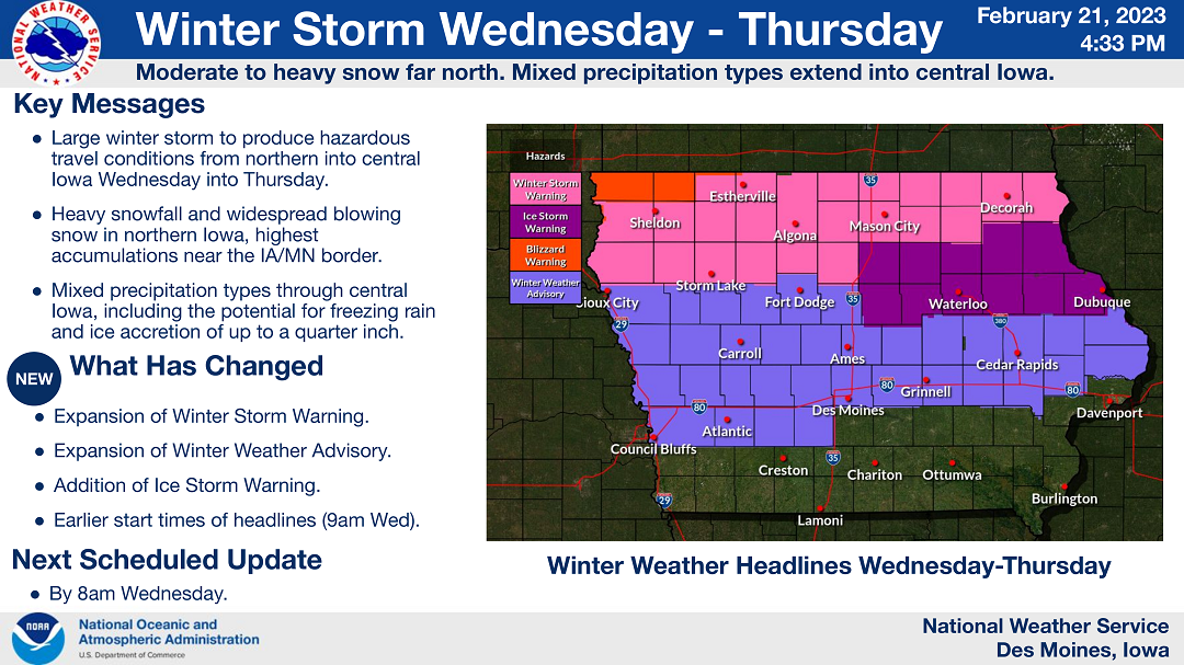
A large storm system will produce hazardous winter travel conditions across central and northern Iowa. Precipitation will begin mid-morning Wednesday and continue into Thursday. Heavy snowfall is likely in far northern Iowa with accumulations pushing 8 inches or more close to the Minnesota and Iowa state border. Strong winds will further aggravate difficult driving conditions by producing widespread blowing snow and visibility reductions to near a quarter mile at times. Mixed precipitation types are more of a concern to the south in central Iowa with a variety of snow, freezing rain, and sleet all possible. Ice accretions may approach or exceed a quarter inch over portions of central and east- central Iowa.
….WINTER STORM WARNING FROM 9 AM WEDNESDAY UNTIL 6 PM THURSDAY FOR CERRO GORDO, WORTH, WINNEBAGO, HANCOCK AND KOSSUTH COUNTIES…
Heavy mixed precipitation expected. Total snow accumulations of 4 to 10 inches and ice accumulations of around one tenth of an inch. Highest snow totals near the state border. Winds gusting as high as 40 mph.
….ICE STORM WARNING FROM 9 AM WEDNESDAY UNTIL 6 PM THURSDAY FOR FRANKLIN AND BUTLER COUNTIES…
Significant icing expected. Total snow and sleet accumulations of up to two inches and ice accumulations of one tenth to three tenths of an inch. Winds gusting as high as 45 mph.
….WINTER STORM WARNING FROM 9 AM WEDNESDAY UNTIL 6 PM THURSDAY FOR FLOYD AND MITCHELL COUNTIES…
Heavy mixed precipitation possible. Total snow accumulations of 3 to 7 inches and ice accumulations of up to three tenths of an inch possible. Winds could gust as high as 40 mph.
…WINTER STORM WARNING FROM 9 AM WEDNESDAY UNTIL 6 PM THURSDAY FOR WRIGHT COUNTY….
Heavy mixed precipitation expected. Total snow and sleet accumulations of 2 to 4 inches and ice accumulations of up to one tenth of an inch. Winds gusting as high as 40 mph.
…WINTER WEATHER ADVISORY UNTIL 6 AM WEDNESDAY…WINTER STORM WARNING FROM 9 AM WEDNESDAY UNTIL 6 PM THURSDAY FOR MOWER COUNTY IN SOUTHERN MINNESOTA…
For the Winter Weather Advisory, snow is expected. Total snow accumulations of 2 to 4 inches. For the Winter Storm Warning, heavy mixed precipitation is expected. Total snow accumulations of 7 to 12 inches and ice accumulations of a light glaze. Winds gusting as high as 40 mph.
….WINTER STORM WARNING FROM 6 AM WEDNESDAY UNTIL NOON THURSDAY FOR FREEBORN AND FARIBAULT COUNTIES IN SOUTHERN MINNESOTA…
Heavy snow is expected. Total snow accumulations of 8 to 11 inches. Winds gusting as high as 40 mph.